
| ||||
| Return to Table of Contents Go to Page [1] [2] [3] [4] [5] [6] [7] [8] [9] [10] [11] [12] [13] [14] [15] [16] [17] [18] [19] [20] [21] [22] [23] [24] [25] [26] [27] [28] [29] [30] [31] [32] [33] [34] [35] [36] [37] [38] [39] [40] [41] [42] [43] [44] [45] [46] [47] [48] [49] [50] [51] | ||||
PAGE 10
| This 1799 plan identifies property (marked
with the large "L") granted by the Governor, Gayoso de Lemos, to Barthélémy Lafon. It
comprised a portion of what is now the area bounded by Common, Carondelet, Canal, and Camp Streets.
Lafon, the architect and surveyor best know for planning the subdivision of large portions of what is now the
Central Business District and the Lower Garden District, was not allowed to put up any permanent buildings
on the property, which was part of the city commons. The area did not develop until after Lafon's death in
1820.
|
The plan also shows the old Spanish customhouse and two of Carondelet's forts--St. Louis, at what is now
the foot of Canal Street, and Bourgogne, between present-day Burgundy and North Rampart Streets, near
Canal--and the wall connecting them. The forts remained in place, though not in use for military purposes,
well into the American period. 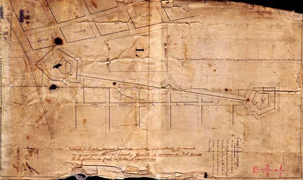
| |||