 |
|
| Images of the CITY | Title | Introduction | Images of the Family |
| Click on the images to view a larger version | |
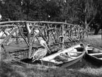 |
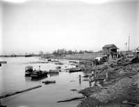
Pelicans, 1899
Just a peaceful scene showing two Louisiana State Birds perched on a skiff next to an interesting rustic bridge somewhere in New Orleans City Park. Photographic opportunities such as this were, of course, much more common at the close of the 19th century in Alexander Allison’s New Orleans than they are in the 21st century city. |
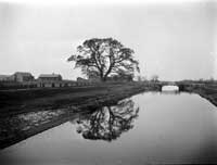 |
London Avenue Canal, North from Gentilly Road, 1900-1905
This photograph was taken shortly after the turn of the 20th century in what was to become the Gentilly section of New Orleans. As an employee of the Sewerage & Water Board, Allison was likely quite familiar with the London Avenue Canal, and probably also appreciated the beauty of this “rural” scene. Actually the background that we see here, over one-hundred years ago, is probably not much different from what is there today, for a large tract of undeveloped land -- the former Rose Hill Cemetery -- remains along the Canal between Virgil Boulevard and Francis W. Gregory Elementary School on Pratt Drive. |
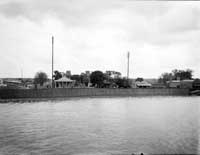 |
West Bank, Algiers, 1900
Allison actually shot this photograph in Harvey, a bit upriver from Algiers and directly across from Louisiana Avenue in uptown New Orleans. The Harvey Canal and its locks (then still under construction) are visible to the left. Also visible in the center, just beyond the houses fronting the River, are the two Gothic turrets of Harvey’s Castle. That structure, built in 1844 as a residence, became the Jefferson Parish court house in 1874 (when Carrollton became part of the city of New Orleans). At the time of this photograph the Castle was being used as the Columbia Gardens, a pleasure resort with sporting activities, dancing, and the like. That venture was short-lived, and the building began to deteriorate thereafter. It was gone by the mid-1920s, but the Canal --now part of the Intracoastal Waterway -- remains a key element in the regional economy. |
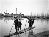 |
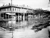
High River at Carrollton, 1900
The young boys on their makeshift raft are not in the Mississippi River proper, but rather on the floodwater that collected behind the wooden revetement or bulkhead where the ship Mars is tied up. This is one of several photographs that Allison shot of the flooded conditions along the River at the turn of the last century. Tulane University professor Oliver Houck used this one on the cover of his recently released book, Down on the Batture (Jackson, University Press of Mississippi, 2010). |
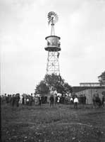 |
The Windmill before the Football Game, 1904
This appears to be a windmill-driven water well on Tulane’s developing uptown campus. The city’s water supply system, operated by the Sewerage & Water Board, had not yet started pumping (that didn’t happen until 1909). It would surely have been within the ability of students and professors in Tulane’s College of Technology to devise a reliable source of fresh water for the University. That’s our guess, anyway. The windmill quite likely was the highest point on the Tulane property and thus the obvious place for the 1904 freshman class to put its mark on the campus. Again, our guess. It’s a fun photograph at any rate! By the way, Tulane’s football team had a 5-2 record in 1904 under coaches Thomas Berry and John Janvier and team captain Ralph Wood. |
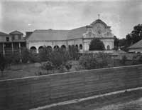 |
Chapel at Old Ursulines Convent, 1905-1915
This chapel was located at the second Ursuline Convent. In the 1820s, the Ursuline nuns moved from their original quarters in the Vieux Carré to a new home on the Mississippi River in the lower part of the city. The chapel, along with the rest of the convent, was demolished to make way for levee construction (and later the Industrial Canal), probably not too long after Allison photographed it. The Ursulines moved to their present property at South Claiborne Avenue and State Street in 1912. |
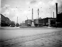 |
Liberty--Canal Street, undated
The Liberty Place monument, erected on the Canal Street neutral ground near Wells Street in 1891, commemorates the battle of September 14, 1874 in which the Crescent City White League attempted to overthrow the Reconstruction government of Louisiana. The obelisk certainly was not controversial when Allison photographed it (probably around 1910), but that changed significantly during the last quarter of the 20th century. In 1989 the monument was temporarily removed from Canal Street; several years later it was relocated to a much less visible spot a block away. The monument is not the only thing missing from this site today. The buildings on both sides of Canal Street between the Custom House and the River were long ago demolished; the left side of the site is now occupied by Harrah’s casino and the right side by the Canal Place shopping mall/hotel/office building complex. And, of course, the horse-drawn wagons have long since been replaced by cars, trucks, SUVs, tour buses, and the like. |
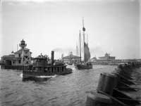 |
Near the Lake, 1905-1910
This photograph shows the tug H.S. Hoskins towing a sloop from the New Basin Canal into Lake Pontchartrain. The fanciful buildings (and the Ferris wheel visible just behind the center structure) were parts of the resort and amusement park at West End. The area declined following development of present-day West End Park by the City of New Orleans; nothing remains of the old resort, and only a small segment of the Canal itself survived the shift from waterborne to motorized vehicular transportation. The New Canal Lighthouse, shown at the left in Allison’s photograph, remained in place despite the changes all around it. Severely damaged by Hurricane Katrina, the structure is scheduled for a full restoration once funding has been secured. |
 |
The Lake Floods the Basin and the Streets around Claiborne Avenue, Orleans Avenue, and St. Peter Street, undated
Allison may have taken this photograph in connection with his position with the Sewerage & Water Board. It shows the uptown side of Orleans Avenue between North Claiborne Avenue and North Robertson Street after high water from Lake Pontchartrain overflowed the nearby Carondelet (Old Basin) Canal. The tall structure at the right is a bell tower that stood on the neutral ground in the middle of the block. By the 1920s the Canal was considered no longer essential to the economy of New Orleans; it was completely filled in by the end of the 1930s. Lafitte Avenue now occupies the old canal right of way; area residents hope to develop a Lafitte Greenway alongside the avenue. |
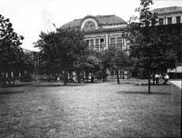 |
New Orleans Public Library, 1905-1910
This is the original home of the New Orleans Public Library, on Camp Street across from Lafayette Square. Built in the 1860s (on the site of Odd Fellows Hall) as St. Patrick’s Hall, the building housed one of the competing Louisiana State Legislatures during the turbulent days of Reconstruction. In later years it served as the Criminal Court House for Orleans Parish; it was where the Italians accused of assassinating Police Chief David Hennessey were tried. The Library moved into the structure after the Court moved to its new home (located, ironically, where the present Main Library now stands). NOPL remained at Lafayette Square until 1906; in that year it moved into temporary quarters so that the U.S. government could demolish St. Patrick’s Hall and erect the new Post Office (now the U.S. Fifth Circuit Court of Appeals). |
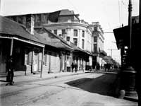 |
French Opera House, 1905-1910
In this photograph the fabulous French Opera House dominates a vastly different Bourbon Street than the gaudy strip of today. Designed by James Gallier and erected in 1859, the Opera House became the cultural centerpiece of New Orleans both for its musical importance and later for its role in the annual carnival celebration. When it was destroyed by fire in 1919, the building belonged to Tulane University thanks to a gift from William R. Irby. After the fire, the site was used for a while as a lumber yard and also as a parking lot. Winthrop Rockefeller built a hotel, Le Downtowner du Vieux Carré, on the site in the mid-1960s, about the same time he was elected governor of Arkansas. The property has gone through several owners, names, and concepts since then; today it is owned by the Tonti family and operated as the Inn on Bourbon Street. |
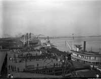 |
Steamboat Landing, below Canal Street Ferry, 1905-1910
In this photograph the Ferry is approaching its terminal, where a group of people await its arrival. There is a small vessel at the wharf in between the ferry landing and the first in the row of steamboats (the J. H. Mengesteamboat landing itself appears to be covered by a small shed, quite different from the typical scene of cotton bales and sugar barrels stacked on the open wharf. Perhaps these were precursors of the present-day covered wharfs. In the foreground are portions of the Poydras Street Wharf and its cargo handling apparatus. The steeples of St. Louis Cathedral are also visible in the distance as are some more modern oceangoing steamships. |
 |
Flooded Wharves, Sand Bag Levees--near Canal Street, undated
The people shown in the middle of the photograph are sitting atop sand bags placed on the Poydras Street Wharf as added protection against the encroachment of high water. The turreted building in the distance at left is the local Anheuser Busch beer depot at Gravier and South Front Streets; the large structure spewing smoke in the center background is the American Sugar Refinery; the building with clock tower at right is the Canal Street ferry terminal; and the small one right in the middle is the Port Commissioners’ office. None of them are around anymore. |
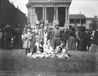 |
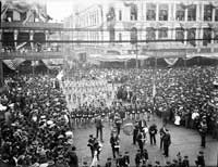
Group of Maskers on St. Charles Avenue, 1905
We expect to see at least some maskers on Mardi Gras in New Orleans, but the sight of parade-going gentlemen wearing coats and ties, and of ladies wearing long skirts and dressy hats is quite different from what one encounters on the streets in the 21st century. It is also interesting to see both black and white folks together in the crowd during what was, after all, the height of the Jim Crow era in the South. Indeed, the Daily Picayune reported on Ash Wednesday that, “Hundreds of negroes were masked, as usual, and mingled with the crowds, and the Indian groups made interesting features for the far-away people who did not know that they were Indians from the rear of Rampart Street exclusively.” |
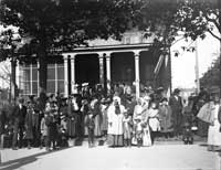 |
Group of Maskers on St. Charles Avenue,1905
Dave Hennen Morris and Miss Hazel Ellis ruled as King and Queen of Carnival on March 7, 1905. Morning temperatures that day were in the mid-60s and the skies were overcast with a trace of rain falling over the course of the day. The weather appears to have had no ill effect on the day, though, as the Daily Picayune proclaimed that, “There has not been an unpleasant incident in the whole Carnival, and that of 1905 will pass into history as one of the most successful ever known.” |
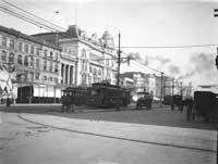 |
The Changing Scene--Grand Opera House and Maison Blanche, 1907
The streetcars are still on Canal Street (21st century versions, though) but much of what we see in this photograph is no longer there. The large ornate structure on the corner of Canal and Dauphine Streets was the old Maison Blanche Building, built ca. 1887 to house D. Mercier and Sons department store. A new MB store and office building (now the Ritz Carlton Hotel) replaced it in 1908. The Grand Opera House, built as the Varieties Theatre in 1871, was demolished around the same time; a Kress department store went up in its place in 1910 (that structure has also since been incorporated into the Ritz Carlton). The row of four-story buildings at the far left was replaced, also in 1910, by the Audubon Building. That edifice has been vacant since before Katrina, but new owners have recently announced plans to convert it into the Hotel Indigo, a 180-room boutique hotel. |
 |
Canal Street from the Chess Club Gallery, during Rex, 1908
This actually shows the 1907 parade. The Rex theme that year was “Visions of the Nations” and the float at the right in the photograph—the Viking ship—was the krewe’s representation of Sweden. Since this is the only one of the Mardi Gras photographs in this exhibit that shows floats, it is the only one that we can date definitively. We have to rely on Allison for the other date identifications; his mistake here, alas, casts some doubt on his overall accuracy. |
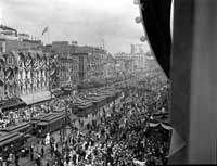 |
Canal Street from the Chess Club Gallery, during Rex, 1908
Allison captured this fantastically busy scene from the Chess, Checker, and Whist Club’s building at the corner of Baronne and Canal Streets (next door to the Grunewald, now Rosevelt, Hotel). It shows the D. H. Holmes department store on the left, the Marks Isaacs store in the middle, and the original Godchaux’s (with the turret) on the left. It is the impressive Mardi Gras crowd and the conglomeration of streetcars, though, that are the focal points of this photograph. |
 |
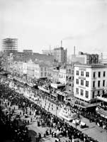
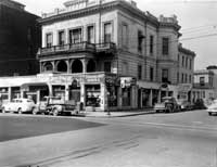
Canal Street at Camp-Chartres Crossing--other Military Escorts, 1908
The massiveness of the Mardi Gras crowd on Canal Street is quite apparent in this photograph. Allison took several other shots (not included in this exhibit) at this location; they show more mature military units instead the youngsters—cadets, perhaps—pictured here. All of the photographs show the original Godchaux’s department store at Canal and Chartres Streets; this one also shows the May’s Drug Store on the opposite corner. The former structure was long ago demolished; its site is now occupied by the New Orleans Marriott Hotel. The May’s building still stands, but it has been many years since the old drug store operated therein. |
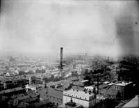 |
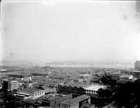
From Maison Blanche Building, towards the Southern Railway Freight Sheds and the Consumers Electric Company Stack, 1910
Birdseye view photographs such as this one, taken from atop the thirteen-story Maison Blanche Building, allowed for wide views of the urban landscape. Here we see a number of interesting structures including St. Louis Cemetery #1 on Basin Street and the old church now known as Our Lady of Guadalupe on North Rampart Street. The 209 foot smoke stack, advertising Bull Durham tobacco, was part of the Consumers Electric plant on Rampart between Bienville and Conti Streets. Also visible just to the right of the cemetery is the freight office building for the Southern Railway (now the Basin Street Station visitor center/office building). The buildings to the left of the cemetery, both along Basin Street and behind it, were part of Storyville, the city’s (in)famous red-light district. |
 |
From Maison Blanche Building, towards Algiers Point,1910
Another angle from the Maison Blanche Building allowed Allison to capture a large portion of the buildings in the upper Vieux Carré. The large domed structure at the far left is the old St. Louis Hotel (now the site of the Omni Royal Orleans Hotel). Just in front of the hotel we see the Civil Courts Building (now home to the Louisiana Supreme Court) while it was under construction. |
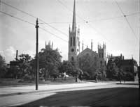 |
First Presbyterian – Lafayette Square, 1910
The First Presbyterian Church opened at this location in 1835 but was destroyed by fire twenty years later. A new church, the one shown here, was constructed in its place and opened in 1857. The 1915 hurricane destroyed the building but it was quickly rebuilt. The U.S. government purchased the property in 1938, demolished the church, and built what is now known as the F. Edward Hebert Federal Building in its place. Materials from the old church were salvaged and used in the construction of the present-day First Presbyterian Church at South Claiborne and Jefferson Avenues. Also visible in the photo are the base of the John McDonogh statue in the foreground and the tower of St. Patrick’s Church behind and to the left of First Presbyterian. |
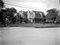 |
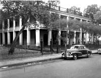
St. Charles Avenue--Jackson Avenue to Philip Street--Whitney's, 1910-1920
Charles A. Whitney and his wife Mary Louise Morgan Whitney built this grand Avenue residence in the early 1870s. Mrs. Whitney was the daughter of Charles Morgan, the New York shipping and railroad magnate; her children founded the Whitney National Bank. S. Frederick Starr in Southern Comfort: The Garden District of New Orleans (New York: Princeton Architectural Press, 1998) states that, “For sheer opulence, no Second Empire mansion in the Garden District ever rivaled the Charles Whitney residence at 2233 St. Charles Avenue.” Starr continues, “…the Whitney mansion became one of the chief sights of the city….To contemporaries, it epitomized the new New Orleans.” The great house, though, would not be part of the even newer New Orleans of the post-World War II era; it was demolished in 1940 and subsequently replaced by the Georgian Apartments. |
 |
Lee Circle. Upper River Quarter, 1910
The car at far left is starting to turn around Lee Circle after passing by a row of buildings on St. Charles Avenue that mostly are not there anymore. All except the three-story house at the end were demolished sometime before 1921 when the Bienville Apartments (more recently the Tivoli Place apartments) were erected. The surviving structure, directly opposite the Lee monument, is now home to the Circle Bar. |
 |
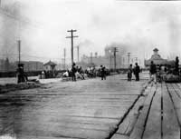
Low River at Carrollton, undated
A major reconstruction of the levee in Carrollton took place around 1910-1911; this photograph may show it in progress. But levee repairs were typically undertaken during periods of low water, so this view could just as well date from an earlier or later time. It is unfortunate that Allison wasn’t more specific as to the location and date of this interesting image. |
 |
Old Sugar Refinery and the Sugar Exchange, 1920
The large multistory building in the center of the photograph is the American Sugar Refinery. It operated in the Vieux Carré from the 1880s into the early 20th century, closing after a new refinery was built downriver in St. Bernard Parish. The light-colored building on the corner across from the refinery is the New Orleans Sugar Exchange. To the right of the Exchange is the office/warehouse building of Delgado & Co., a major sugar brokerage firm. The small open space in front of the latter two buildings is Sugar Exchange Park. None of this remains today—a sea of surface parking lots occupies what once was an important center for the sugar industry in Louisiana. Interestingly, though, the structure at the extreme right in Allison’s photograph is still standing. It and two adjacent buildings form a small island in the midst of that parking lot sea. |
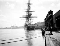 |
Constitution--"Old Ironsides," 1932
One of the most famous American warships— hero of the War of 1812—the U.S.S. Constitution, popularly known as Old Ironsides, underwent a major restoration in the late 1920s. To celebrate the completion of that project the ship embarked on a ninety port tour during the years 1931-1934. The New Orleans leg of that tour coincided with the 1932 Carnival season (it was here from January 27 until February 13; Mardi Gras that year was February 9). Allison was able to photograph the historic vessel as it lay anchored at the Toulouse Street wharf. A line of visitors waiting to go aboard is visible to the right of the ship; more than 193,000 men, women, and children boarded the ship while it was in the Crescent City. |
 |
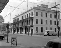
Washington Artillery Hall, 1948
This large building (the one with the Buick sign on its front) dates from the 1860s when it was built as Exposition Hall. It fronted on St. Charles Street and extended all the way through the square (bounded by Girod and Julia Streets) to Carondelet Street. In 1878 the Washington Artillery purchased the structure and used the ground floor for its armory. The second floor was divided into two large ballrooms; Rex held its balls there for a number of years. After World War II the Artillery moved its operations to Jackson Barracks and sold the St. Charles property. The Hall was demolished in the early 1950s to make way for construction of a new office building. The building to the left of the Hall (then the Hotel Patin) is still standing, as are at least some of the older structures closer to Girod Street. |
 |
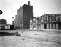
Charity Hospital Ambulance House, 1949
This building on the corner of Tulane Avenue and South Villere Street was no longer housing ambulances when Allison photographed it shortly before its demolition. Charity built a new ambulance station in the late 1930s and the old building had been serving as a garage for some time. Its replacement, the Dibert-Butterworth Building, still stands as does the structure shown to the left of the ambulance house in the photograph. Note also the streetcar at far right; buses (actually trackless trolleys) did not come to Tulane Avenue until 1951. |
 |
France and Chartres Streets, Olivier—later St. Mary’s School, 1949
The David Olivier House was built ca. 1820 on Chartres between Mazant and France Streets. The property was purchased in 1840 by the Catholic Orphans Association of New Orleans and subsequently operated as the St. Mary’s Orphan Asylum. The boy orphans later were moved to what became Holy Cross College (located prior to Hurricane Katrina just across the Industrial Canal). Still later the girls relocated to what became the Academy of the Holy Angels on North Rampart Street (that school closed its doors in 1992). For many years the property lay more or less vacant and unused. The photograph shows the Olivier House along with later additions (said to have been designed by the architect Henry Howard) during the Asylum’s 1949 demolition. Citizen efforts to save the historic structure ultimately failed, but the Louisiana Landmarks Society came into being as a result of those efforts. The site remains vacant. |
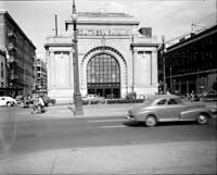 |
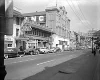
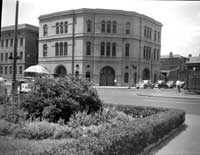
Terminal Station—Southern Railway, 1950
The Southern Railway Terminal stood on the neutral ground of Basin Street at its intersection with Canal Street from 1908 until its demolition in 1956, following the opening of the new Union Passenger Terminal on Loyola Avenue. Designed by Daniel Burnham, the influential Chicago architect whose works include the Flatiron Building in New York City and Washington, D. C.’s Union Station, the Terminal was a dominating presence on Canal Street. Before it was torn down there was some discussion of adapting the structure for use as a new main public library in order to save the architectural jewel for New Orleans. Though the Terminal is gone, its two neighbors, barely visible in the photograph, remain standing today—the old Krauss department store on the left (recently renovated into condominiums) and the Saenger Theatre on the right (still closed following the post-Katrina flood). |
 |
St. Charles Avenue--Upper Lake Corner with Julia Street (General Butler's HQ), 1951
This sad scene from 1951 became even sadder in 1965 when the grandiose Campbell Mansion fell to the wrecking ball. It was designed by the architect Lewis Reynolds in the late 1850s for Dr. George W. Campbell and was recognized as one of the finest residences in the city. During the Civil War it was seized by the federal authorities and used as their headquarters. Here, though, we see it desecrated by a tacky storefront addition (housing, among other things, an early version of the Hummingbird Grill which later moved across the street). The final indignity came in 1965 when the formerly great house was demolished, according to the Friends of the Cabildo, for a used car lot. The small structure at the far right in the photograph—the carriage house for the residence—for some reason is still standing. |
 |
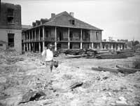
Annunciation Street corner Thalia Street--Old Solet [Saulet] House (Mercy Hospital), 1951
This plantation home in the middle of the city of New Orleans had an interesting and distinguished history. According to the Friends of the Cabildo it dates back to about 1763 (rebuilt in 1832) when the Faubourg Saulet was created from a portion of the old Jesuit plantation. After the Saulet family sold it, the house served as the St. Simeon’s Select School and later as the parochial school for St. Theresa of Avila Parish. For a while after that the building housed St. Luke’s Private Sanitarium, a mental hospital. The house returned to the original family when Leona Saulet Soniat purchased it; she honored her late husband in 1924 by establishing the Leonce M. Sonial Memorial Mercy Hospital. When the new Mercy Hospital opened on South Jefferson Davis Parkway, the Annunciation Street facility was closed. The old Saulet home was demolished in 1959 and replaced by a Schwegmann’s Supermarket (more recently a Robert’s Fresh Market); the store has been vacant since Katrina. |
 |
Camp Street--St. Joseph Street towards Howard Avenue, 1952
Allison photographed these five residential buildings shortly before they were demolished to make way for a gymnasium for the neighboring Lee Circle YMCA. Allison noted that the buildings had been designed by James Gallier, but volume 2 of the Friends of the Cabildo New Orleans Architecture series attributes them instead to Henry Howard, another superb antebellum architect in the Crescent City. That volume describes the structures as, “five splendid three-story brick houses with cast iron balconies.” They were erected in 1852 by John K. Collins for Thomas Hale; a century later, they were gone—even the gymnasium is no longer. |
 |
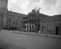
Entrance to Girod Street, January 1953
The Girod Street Cemetery was the city’s oldest Protestant cemetery, opened by the wardens of Christ Church in 1822. The cemetery, which had fallen into disrepair by the time Allison took this photograph, was demolished in 1957. The cemetery stood roughly where the now shuttered—since the flood-- New Orleans Centre shopping mall (next to the Superdome) stands today. Parts of Charity Hospital and the Veterans Administration Hospital are visible in the background. |
 |
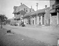
St. John’s Church and School, December 22, 1956
Allison took a number of “before” photos of the area in the vicinity of the approaches to the new Mississippi River Bridge, which opened to traffic in October 1958. St. John the Baptist Church on Dryades (now Oretha Castle Haley Boulevard), between Clio and Calliope Streets is immediately adjacent to one of those approaches. This photograph shows the parish school, apparently being prepared for demolition, still standing on the corner of Dryades and Calliope. The church, though quite close to the elevated roadway, was spared; its gold dome provides something quite impressive for commuters to gaze upon while they’re stuck in traffic. |
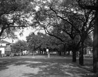 |
North Claiborne at Esplanade Avenue, November 1, 1956
Just about ten years after Allison shot this photograph the live oak trees on the North Claiborne neutral ground were uprooted so that construction of the elevated Interstate Highway 10 could proceed. The highway project not only took away the oak trees, it also drastically changed the economic and social life of the adjacent neighborhoods. Proposals are under consideration to dismantle the Interstate and restore the surface-level Avenue to once again be the “Main Street” of black Creole New Orleans. |
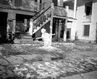 |
Tilting Snowman, Feb. 19, 1958
This tipsy-looking fellow appears to be out in front of 2316 General Pershing Street, right next door to the Allison home. Allison photographed him on the day after Mardi Gras and a full week after 1.3 inches of snow fell on the Crescent City. Allison’s camera surely was not the only one out in the cold snapping shots that day. |
|
|